Le Meix-Saint-Epoing
| Le Meix-Saint-Epoing | |
|---|---|
 Kostel | |
| Poloha | |
| Souřadnice | 48°42′ s. š., 3°39′1″ v. d. |
| Nadmořská výška | 155–214 m n. m. |
| Časové pásmo | UTC+01:00 (standardní čas) UTC+02:00 (letní čas) |
| Stát | |
| Region | Grand Est |
| Departement | Marne |
| Arrondissement | Épernay |
| Kanton | Sézanne-Brie et Champagne |
 Le Meix-Saint-Epoing | |
| Rozloha a obyvatelstvo | |
| Rozloha | 11,29 km²[1] |
| Počet obyvatel | 295 (2022)[2] |
| Hustota zalidnění | 26,1 obyv./km² |
| Správa | |
| mairie | |
| PSČ | 51120 |
| INSEE | 51360 |
| Některá data mohou pocházet z datové položky. | |
Le Meix-Saint-Epoing je francouzská obec v departementu Marne v regionu Grand Est. Žije zde 295[2] obyvatel.
Geografie
Sousední obce

|
La Noue | Mœurs-Verdey | Vindey |
|
| Esternay Châtillon-sur-Morin |
Saudoy | |||
| La Forestière | Barbonne-Fayel |
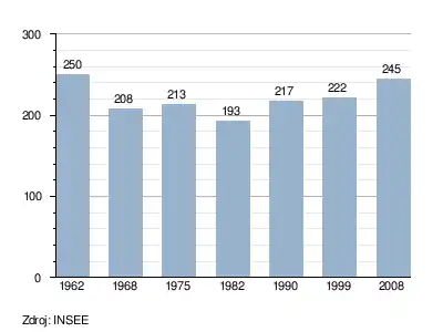
Vývoj počtu obyvatel
Odkazy
Reference
- ↑ répertoire géographique des communes. Institut national de l'information géographique et forestière. [cit. 2015-10-26].
- ↑ a b Populations légales 2022. INSEE. 19. prosince 2024. Dostupné online.
Související články
Externí odkazy
 Obrázky, zvuky či videa k tématu Le Meix-Saint-Epoing na Wikimedia Commons
Portály: Francie | Geografie