Kanton Senlis
| Kanton Senlis | |
|---|---|
| Geografie | |
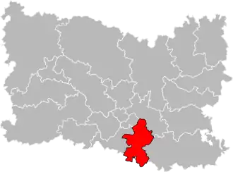 Kanton na mapě departementu Oise | |
| Hlavní město | Senlis |
| Souřadnice | 49°12′26″ s. š., 2°35′12″ v. d. |
| Rozloha | 168,01 km² |
| Geodata (OSM) | OSM, WMF |
| Obyvatelstvo | |
| Počet obyvatel | 33 251 (2012) |
| Hustota zalidnění | 197,9 obyv./km² |
| Správa regionu | |
| Stát | |
| Region | Hauts-de-France |
| Departement | Oise |
| Arrondissement | Senlis |
| Druh celku | Kanton |
| Podřízené celky | Obce (počet: 14) |
| Vznik | 22. března 2015 |
| Některá data mohou pocházet z datové položky. | |
Kanton Senlis (fr. Canton de Senlis) je francouzský kanton v departementu Oise v regionu Hauts-de-France. Skládá se ze 14 obcí. Před reformou kantonů 2014 ho tvořilo 17 obcí.
Obce kantonu
od roku 2015:
- Aumont-en-Halatte
- Avilly-Saint-Léonard
- Chamant
- La Chapelle-en-Serval
- Courteuil
- Fleurines
- Mont-l'Évêque
- Mortefontaine
- Orry-la-Ville
- Plailly
- Pontarmé
- Senlis
- Thiers-sur-Thève
- Vineuil-Saint-Firmin
před rokem 2015:
- Aumont-en-Halatte
- Avilly-Saint-Léonard
- Barbery
- Chamant
- La Chapelle-en-Serval
- Courteuil
- Montépilloy
- Mont-l'Évêque
- Mortefontaine
- Ognon
- Orry-la-Ville
- Plailly
- Pontarmé
- Senlis
- Thiers-sur-Thève
- Villers-Saint-Frambourg
- Vineuil-Saint-Firmin
Externí odkazy
Portály: Francie